The project focuses on the Tamar Estuary, located in Plymouth, a coastal community south west of England that strives for marine tourism. In response to marine tourism, Plymouth intends to expand its primary industry by proposing a national marine park. However, the existing fishing industry is slowly being forgotten by absence of a developed marine spatial planning and a lack of space along the coastline.
Intertidal mediations examine the development of coastal communities, cities located along the coast, in the United Kingdom. Many of these cities have a primary mode of production such as marine tourism, fishing, wind farming, agriculture, etc. As the coastal communities develop, natural resources are exploited through the means of mode of production (Cosgrove 52). However, the exploitation of natural resources, in this case the sea and coastline, provides a conflict between the different actors, creating competition for marine real estate. The marine resource in the United Kingdom are competed for along the coastline. There is a disproportion of coastal ownership and development. Disproportion of coastal economies are due to the lack of a developed coastal and marine spatial planning. Many of these communities are focusing on primary mode of production without the alternative means of economic balance.
The project looks specifically at the intertidal areas in Plymouth, which provides an opportunity to expand into other industries while accommodating for the existing fishing community and a future national marine park. The research looks at redefining marine management by informing a design policy that influences the decision making of today’s marine spatial planning. Through various tests, the project looks at physical and digital techniques that informs a diverse landscape that allows for diverse economic prosperity. Through the role of a designer, the deployed techniques include interactive mapping and physical low tide simulation model to assist design decision internally, but not limited to internal use.
Through careful case studies, the project seeks to utilize structures at the architectural scale to better inform the development of diverse marine use at the intertidal areas within Plymouth. This scale can be extrapolated at multiple scales to better inform decision making among the local actors. Through various scenarios, the project works through the variable of time: economic fluctuations, constant changing of tides, sediment accumulation and eroding processes.
Plymouth plays a big role in the fishing business within the United Kingdom. This is an underappreciated industry and the United Kingdom takes a big role in this economy. Since Plymouth is the main fish market hub in the south west, the city supplies fish throughout the entire UK. This will be further discussed in chapter 2. Fish is important the United Kingdom. In the larger scale of the fishing industry, more than half of the fish in the United Kingdom are exported outside of the country. While most UK consumed fish are imported mostly from the European Union. The global economy plays a role in the territory it faces with the fishing policies and maritime boundary limits (Carpenter 4). As the mode of fish production increases, the economy plays a role in shaping the territoriality of the economic sea boundaries (Elden 800). Through capitalistic interests, nautical boundaries are drawn to define where fishermen can go.
The fishing industry is a complex system with different quotas for each fish and different exclusive economic zones. Most of the fish caught in the United Kingdom exported to a foreign country, approximately 76% (Carpenter 4). Since the seas have economic exclusive zones, EEZ, fishermen throughout Europe and United Kingdom fish in the same EEZ and 12 nautical mile sea limit boundary. By allowing the fish vessels to catch seafood in the same boundaries, European Union and United Kingdom are able to share the allowable catches by trading amongst each other(Carpenter 18). However, Brexit plays a role of gaining British seas all for themselves. This notion of British seas lead to a surplus of fish since Britain does not have enough existing fish infrastructure to process all fish for trade.

This stems into negotiating territorial seas between European Union and the United Kingdom. The imports and exports are currently exhibiting insufficient middlemen management in the fishery business. The territorial sea conditions begin to influence the supply and demand of the market, thus creating inefficient movement of fish from one facility to another.
The project further coordinates with a non-profit organization, New Economic Foundation, to develop a more resilient coastal community. Many coastal communities rely on a primary economic strategy, which lends itself to instability and unhealthy local economy (Belata 9). The team coordinated with the organization to understand the importance of a diverse economy and understand the need of stakeholders. Various stakeholders are left forgotten due to the incremental development of coastal communities, such as local fishers in East Sussex, Graham’s story to build a better coastal community (Belata 32). The New Economic Foundation advocates for small actors to provide a resilient community, allowing for communities to retain economic alternatives. In relevance to Plymouth, New Economic Foundation and a diverse economy is further discussed in chapter 4.

This chapter looks at Plymouth, Britain’s Ocean City. The city prides itself on its marine activities. However, existing conflict occurs in the coastal areas of Plymouth, especially in the Sutton Harbour. In the map to the left, there is a conflicting interest with the marine tourism outnumbering other harbour uses. This indicates a high concentration of marine tourism economy, with little interest in other industries. The fishing community feels constrained and without further room to grow. This is problematic to Plymouth because the city is not diversifying its economic portfolio. Chapter 4 further discusses the negative impacts relying on one primary marine industry in the Blue New Deal. Additionally, this chapter further discusses the plans Plymouth is proposing in the future in celebration of its marine heritage and marine management.
Conflicting Nautical Quays
As mention earlier in the case of Sutton Harbour, where majority of the docking space were dedicated to marina, fisher community in the area felt intimidated by the idea of Marine Park that promotes more tourism economic growth. Although the fishing community brings 13 million pounds per year to Plymouth economy and also provide fish throughout the entire UK, Marine Park would still pushing out the fishery business gradually and forcing Plymouth Fisheries to further relocate and lose its economic importance that built-up over many generations. The fisher community does not want that to happen because eventually with the growth of tourism economy under the promotion of Marine Park, fishers would have nowhere else to dock their boats. Therefore, with the feeling of left out in the future economy, fishermen raised protests in the city to advocate for their importance in Plymouth harbours. Currently, there are many ongoing protests and backlashes from the fishing communities and complains are associated with the lack of boating spaces for fishers to stay.
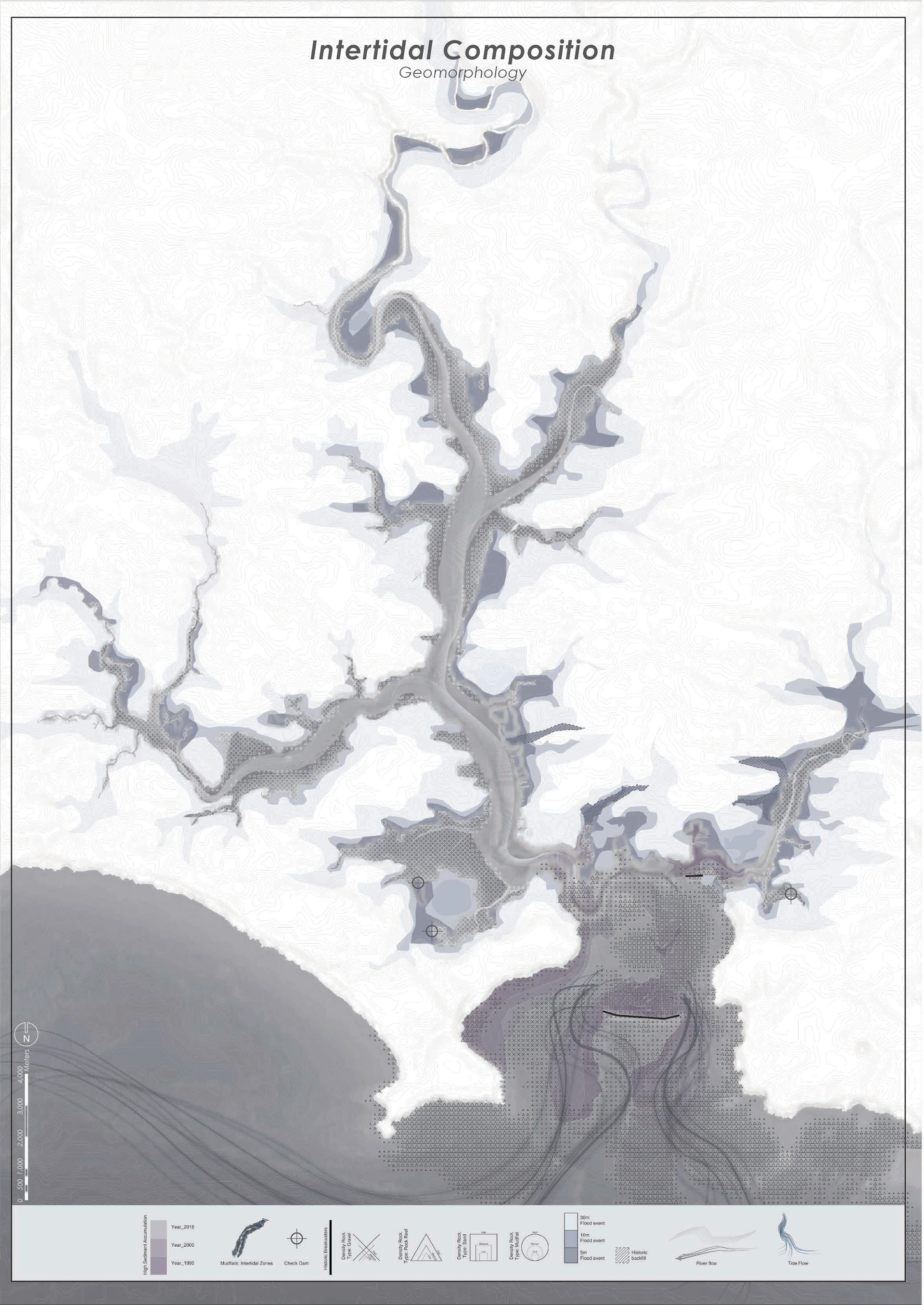
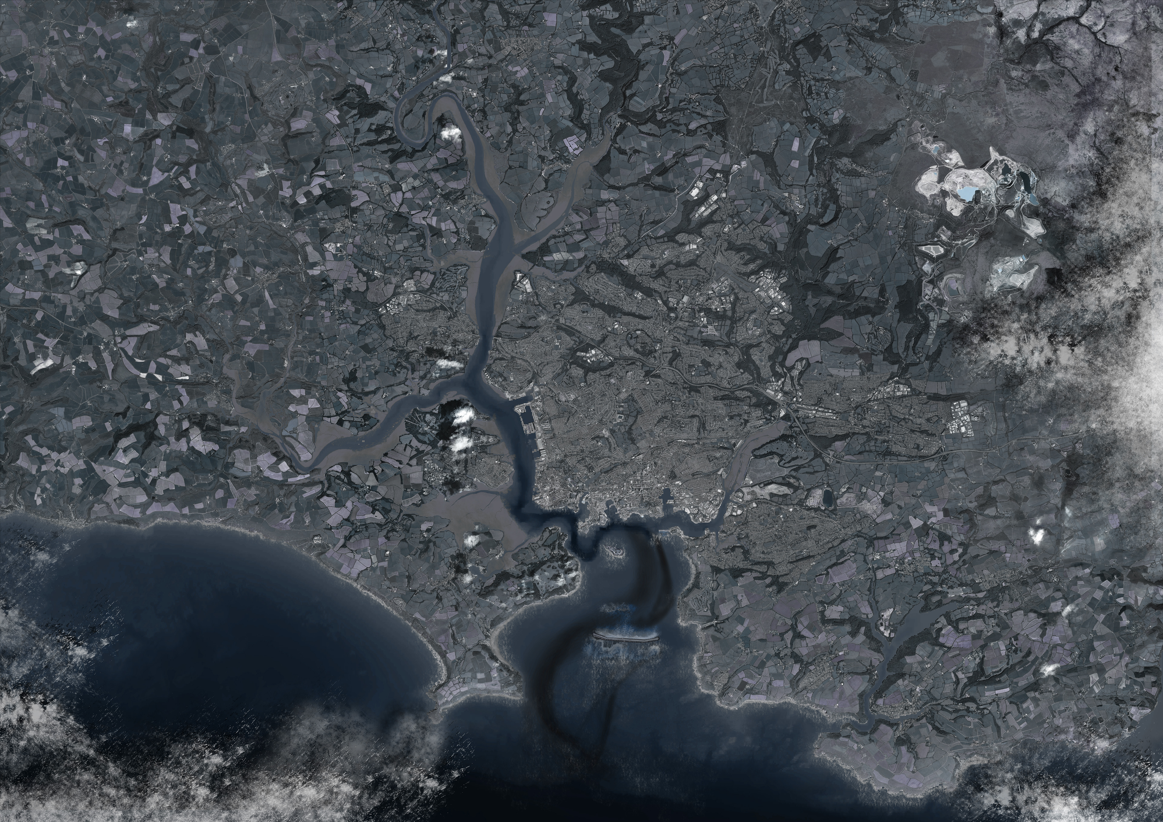
In order to find a way to intervene the site and construct new landscape typology for the future economy of Plymouth, the natural formation of the estuarine environment needs to be well comprehended and integrated into the later design strategy. By carefully examining the built environment of the coast line and study the intertidal movement in the mudflat area along the entire estuary, the group were able to identify the essential forces that alters and shapes the land. Besides the nature, historical human settlement and infrastructure also reshapes the boundaries of the coastline and gradually change the composition of sediment placement and distribution over decades. All those traits are particularly intriguing for the group to further move on and speculations about those geomorphological processes could be justified for the scope of work. This chapter is about the preliminary study on the current coastal infrastructure and its association with geomorphological forces over long period of time.
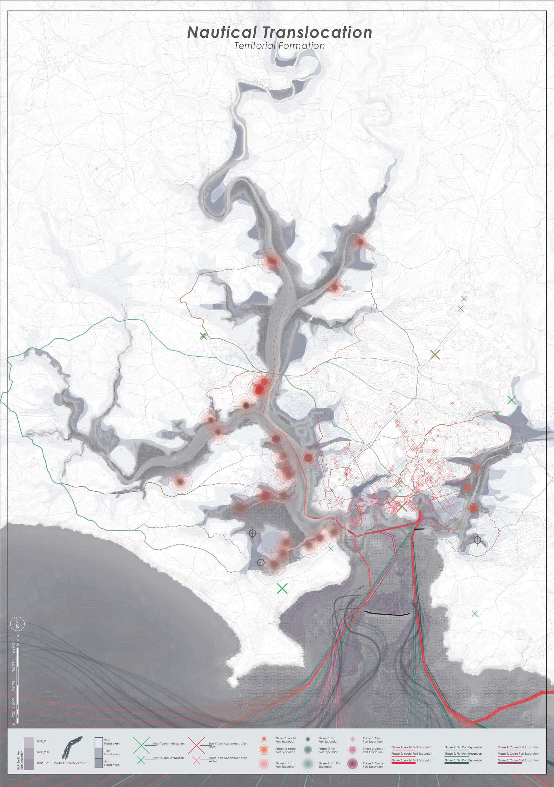
Plymouth is currently focusing its economy towards a marine tourist attraction. However, this have some negative implications to the entire sound and the city. As seen in the drawing in the left, the varying routes and potential port locations indicate a projected scenario of development. By developing more ports along the coast line of Plymouth, the harbour beings to exhibit an influx of activities that potentially thwarts the existing development of smaller industries such as the fishing community. This is due to the local member of parliament, Luke Pollard, advocating for a national marine park to be imposed along the greater sound of Plymouth. National marine park impact would include more of a tourist destination and advertisement for the city rather than a preservation of natural resources (Glegg). Heavy marine activities occur because the city operates within its marine environment as an opportunity to exploit natural resources (Cosgrove 49). Plymouth primarily navigates through its marine economy. However, Plymouth lacks the ability to rely on multiple economies. This project looks at alternatives to inform design policy to incorporate a diverse economy as discussed later in the chapter.
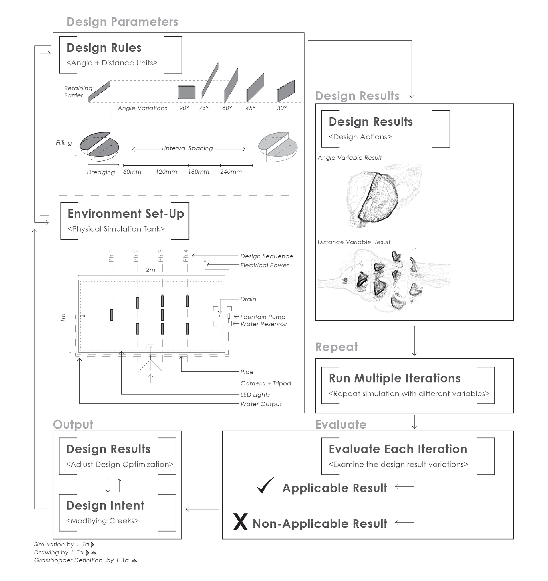
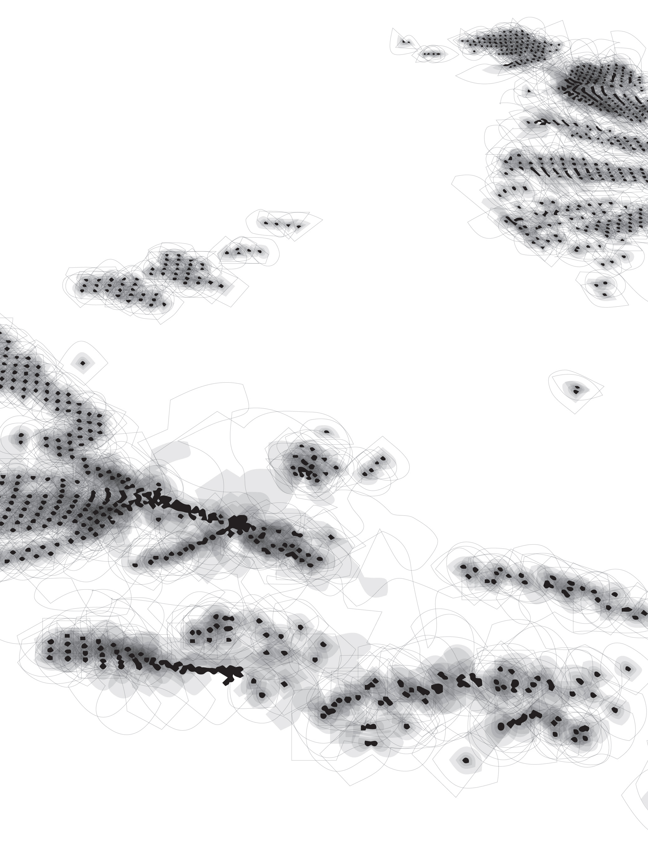
The project continues to explore the social conditions in which there is a lack of port space in Plymouth and examine the existing geomorphological conditions as an opportunity to change the way major actors utilizes the space in Plymouth. This chapter discusses the three digital techniques to inform design decisions, assist the understanding of existing geomorphological conditions, and simulate low tide conditions. The first tool focuses on the interactive and dynamic nature of javascript, Processing, as a way informing design decision by giving site constraints and path dependent routes to allow for future potential development along the coast. The second tool utilizes a flooding simulation tool, CAESAR, that examines the tide flooding conditions to better understand Plymouth’s intertidal areas. Finally, the third tool utilizes generative design, Grasshopper Firefly, to capture imagery of a physical water and sediment simulation to better inform long term change and development of existing creeks.
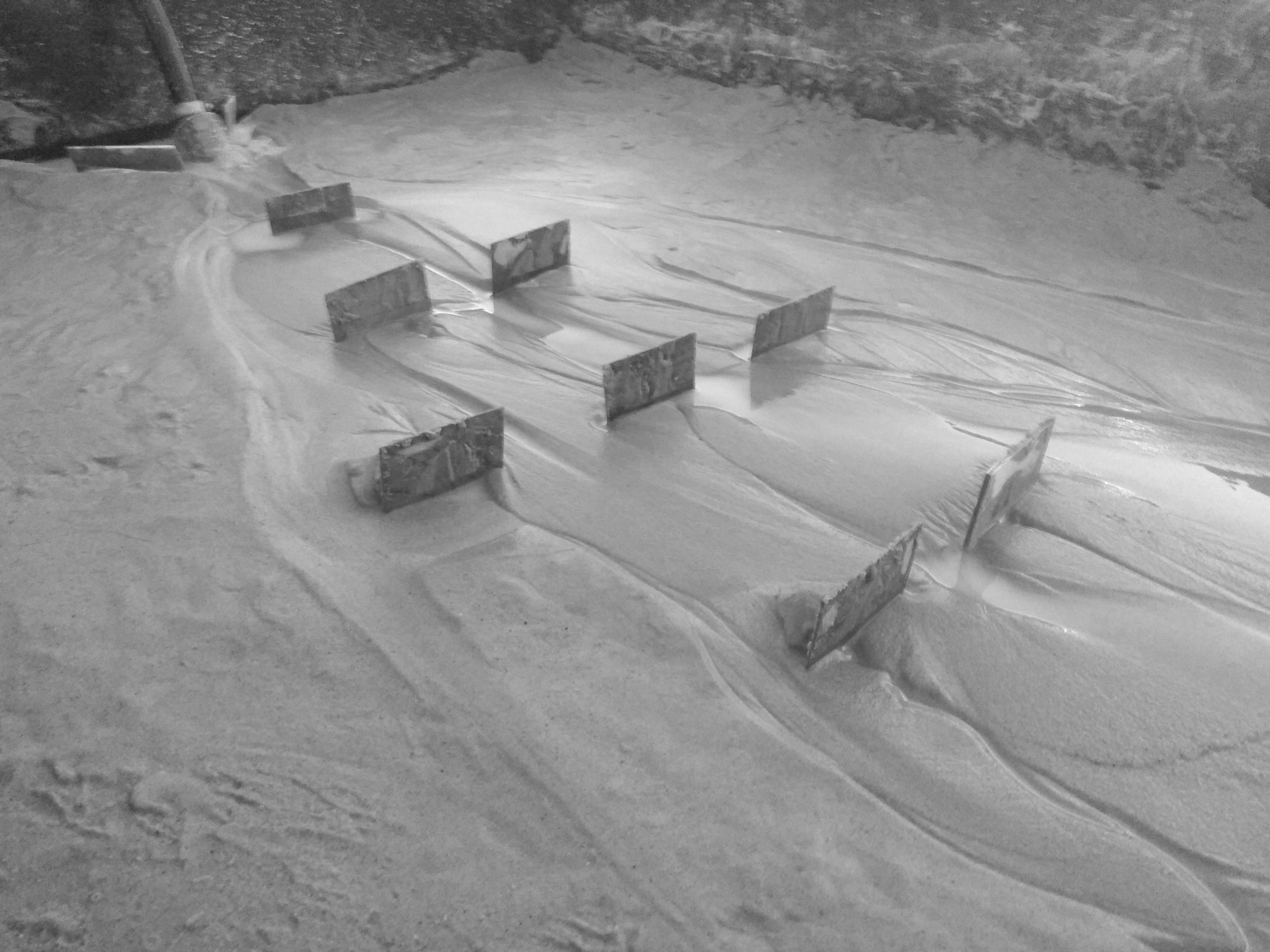
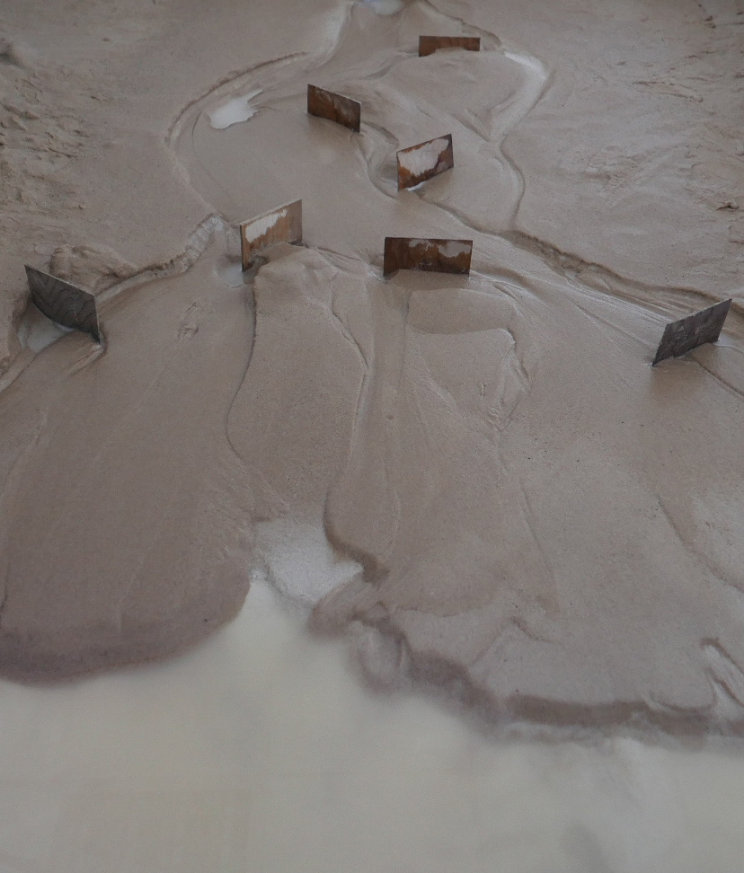
This section of the chapter focuses on the merging of the physical simulation and computer vision learning. The project utilizes generative design to detect the changing physical photos in the simulation. In the diagram below, the experiment below curates a juxtaposition of wood barriers within a sand and water environment. The image to the right examines the dynamic shift of sediment movement, creating varying lines of water boundary. This experiment allowed us to understand the principles of that time that is interwoven into the design in chapter 7, Collective Creek Formations. As a result, the physical simulation was instrumental at the individual creek scale.


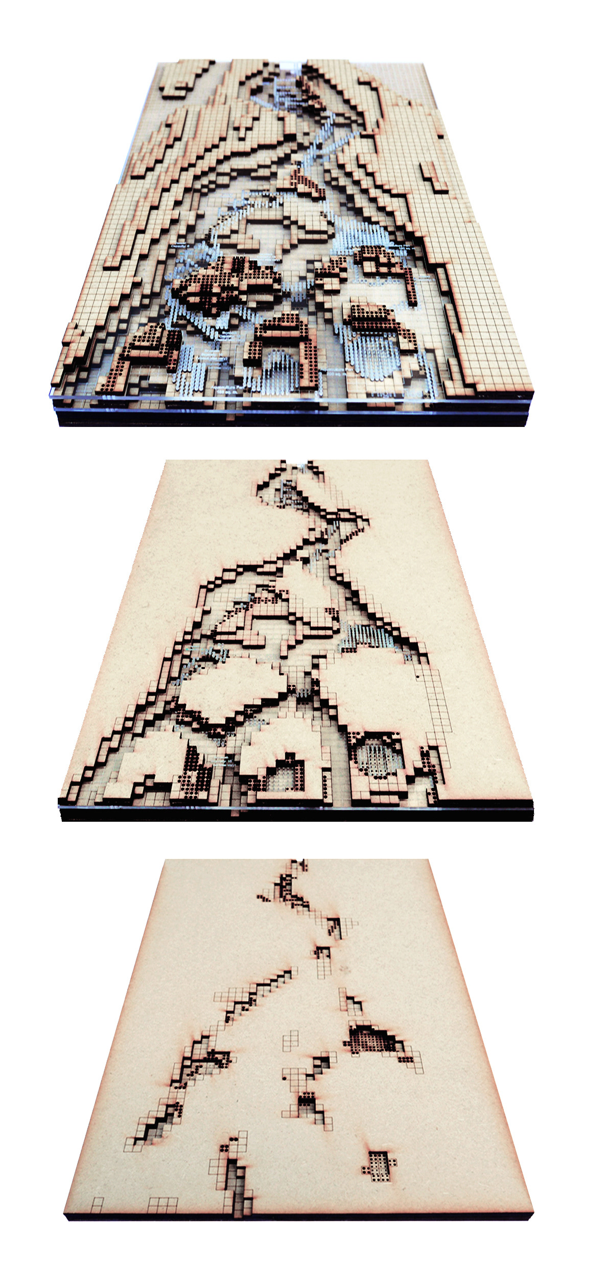
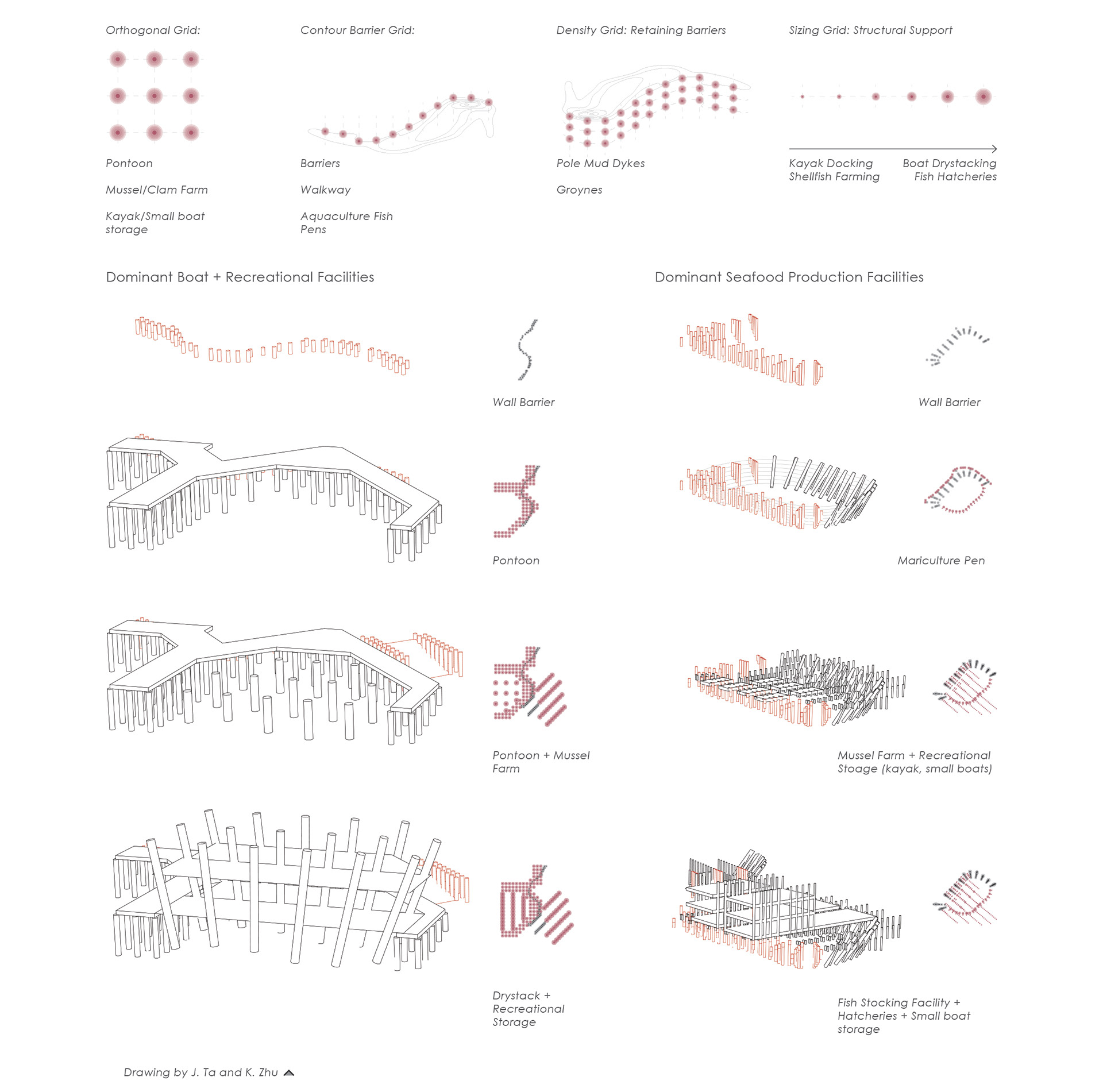
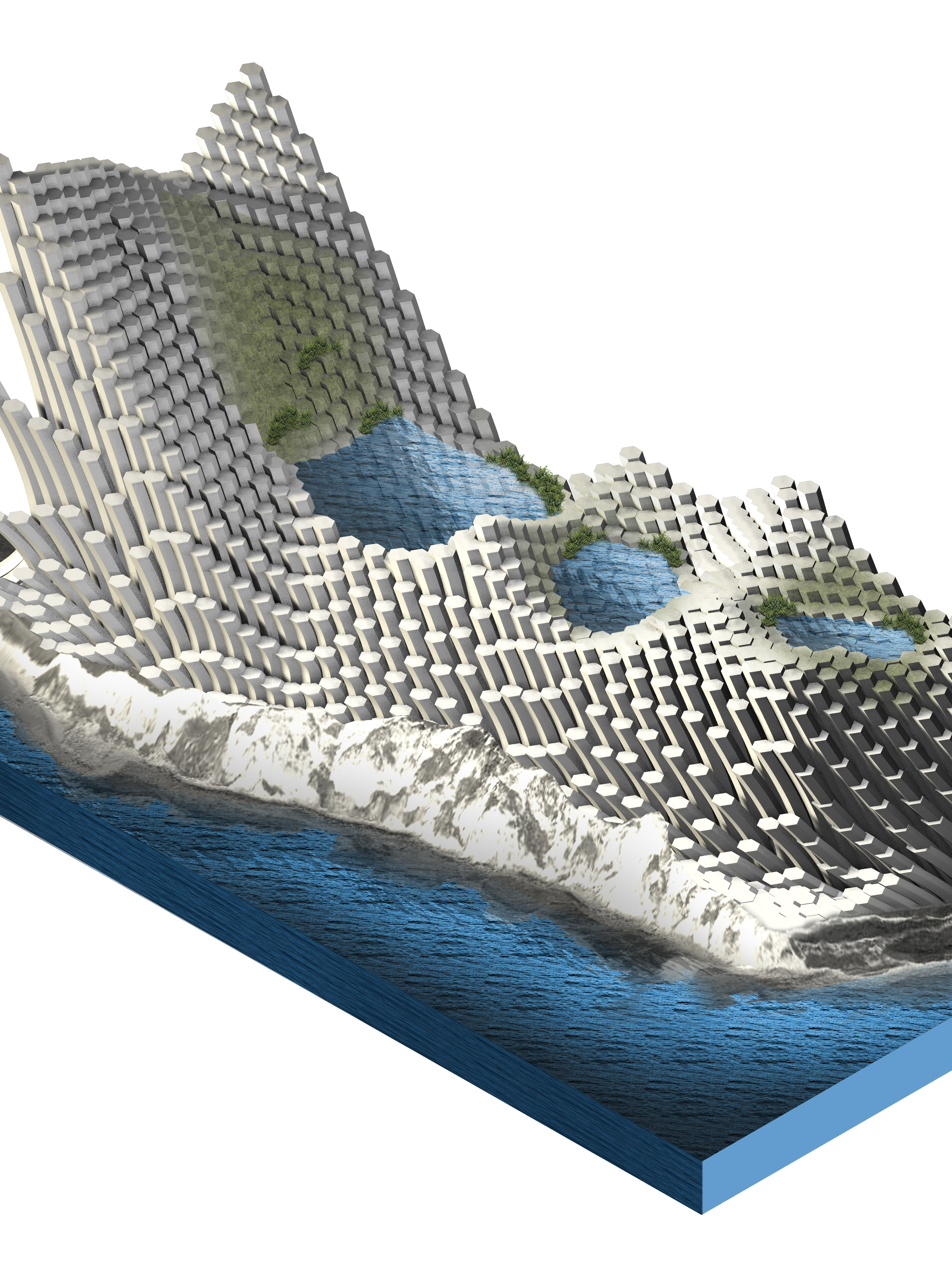
In the drawings below, the project looks at variation of vertical archetypes. These structures form kit of parts that builds upon the sequential time and everchanging landscape. Through a series of growing structures, the development of boat storage and seafood production continue to shift. The structures grow into boat and recreational facilities or seafood production.
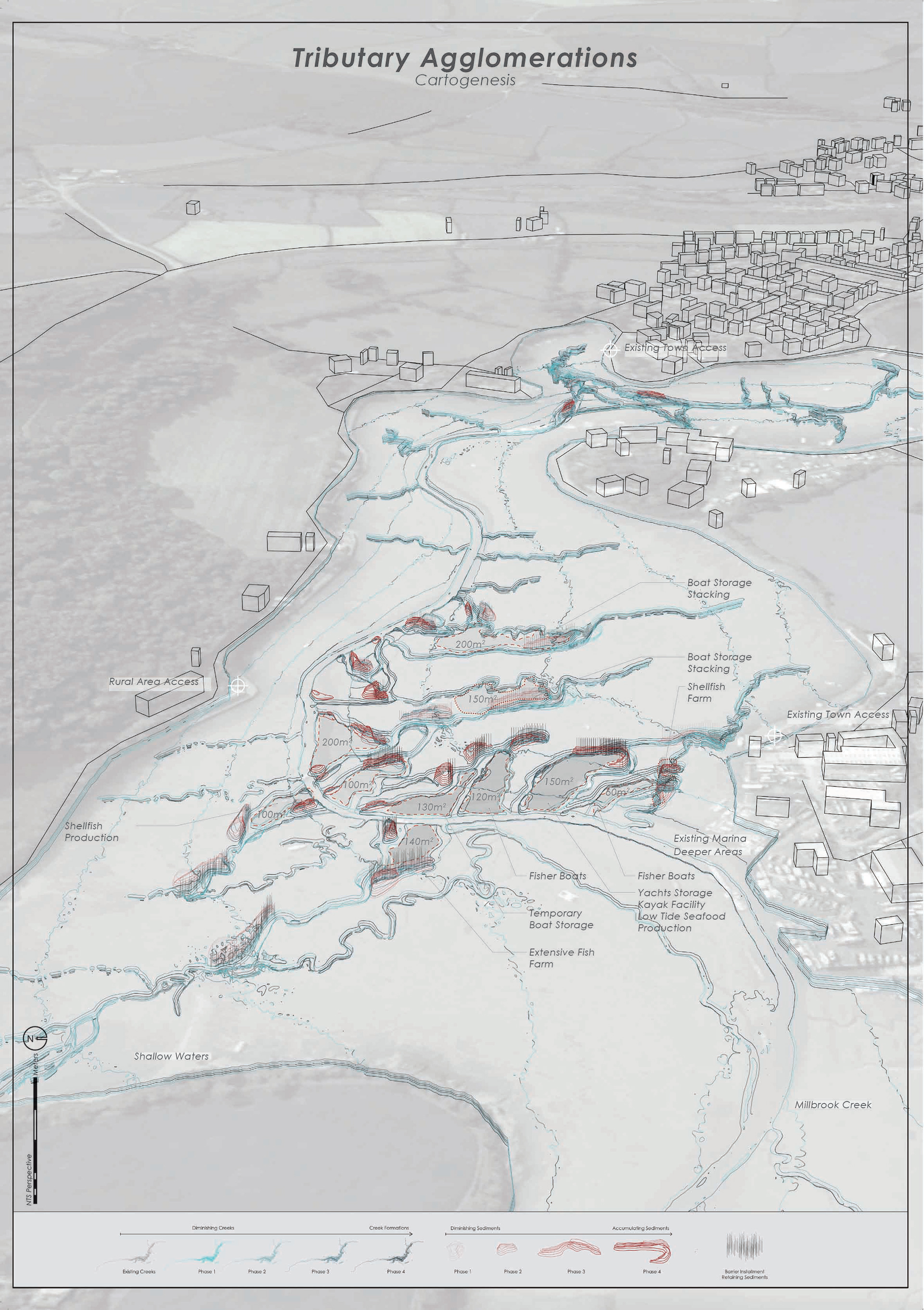
In this chapter, the project examines the relationship between the intertidal areas with the opportunities posed in chapter 2. Intertidal areas discussed in chapter 3 looks at the existing conditions of creek formations and the development of local ports. Many of these develop through the maintenance of dredging and creating barrier marinas. In the case smaller marinas, intertidal areas utilize pontoons that dock itself to adjacent creeks and rivers to allow boat launching to occur in low tide conditions. Tributary agglomerations modify existing creeks to develop varying creek formations that allow for a diverse programmatic use.
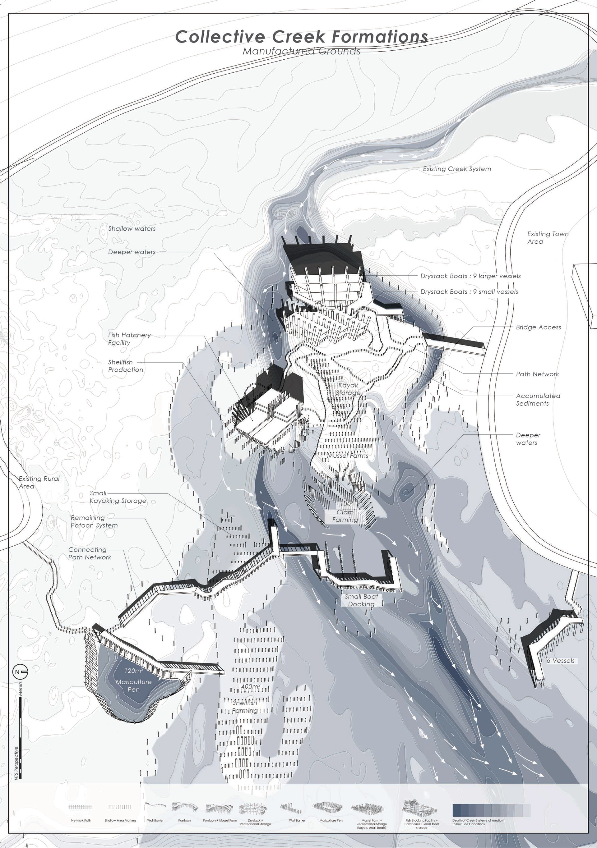
Collective Creek Formations is a composition of challenging the conventional way of information design at a higher level. Today, land and sea are treated differently. However, sea and land have the same territory implications and spatial quality. The sea is simply diluted land with a fluid spatial quality (Steinberg 250). The project examines the blurring between land and water. Through design strategy at the architectural scale, creek formations are manipulated with vertical elements, merging the programmatic use on land and water. The chapter further discusses the development organizing through time as a response to future scenarios of coastal development.
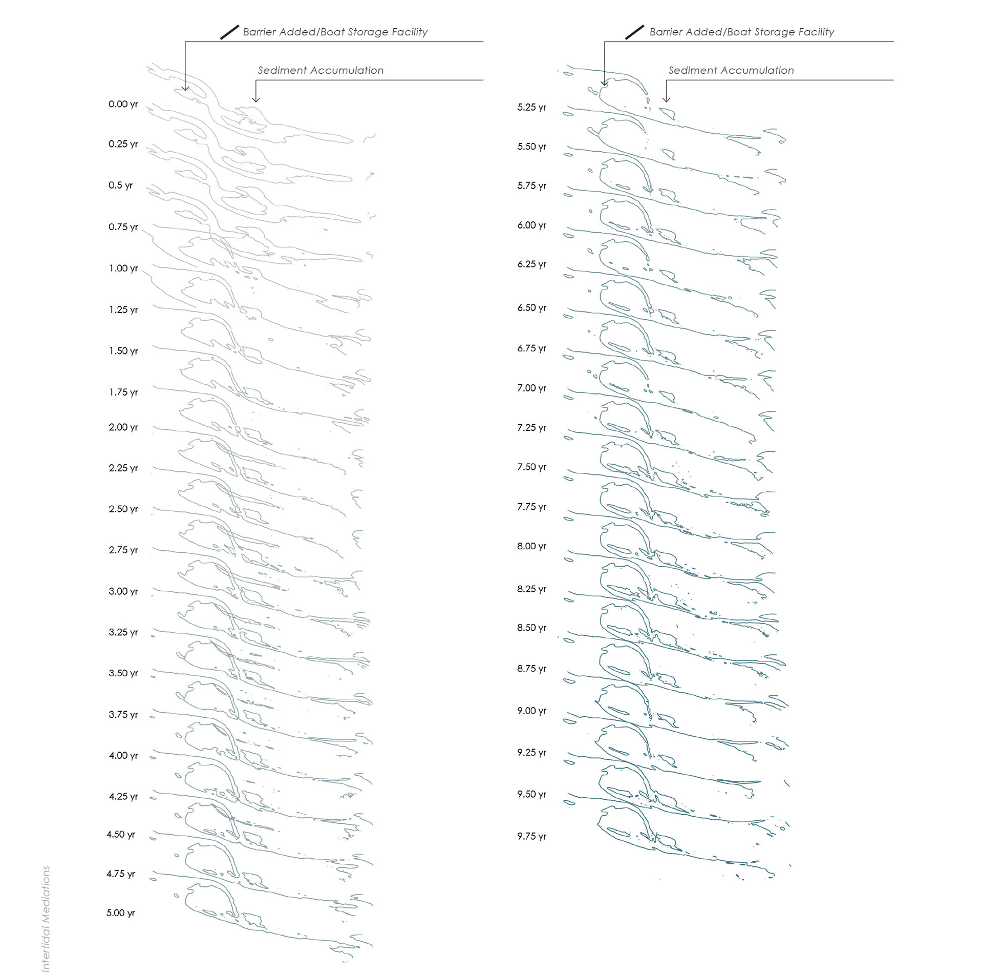
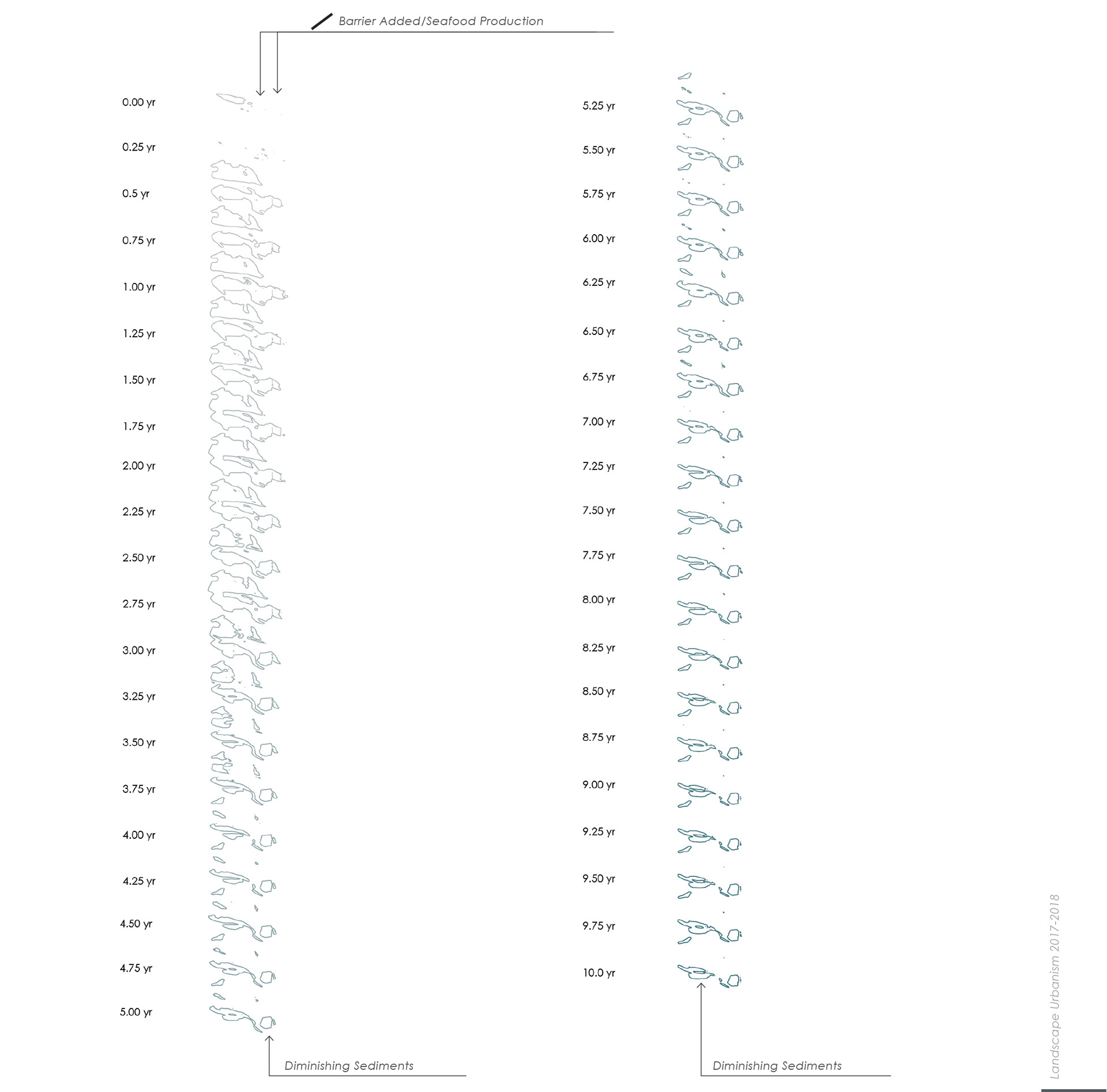
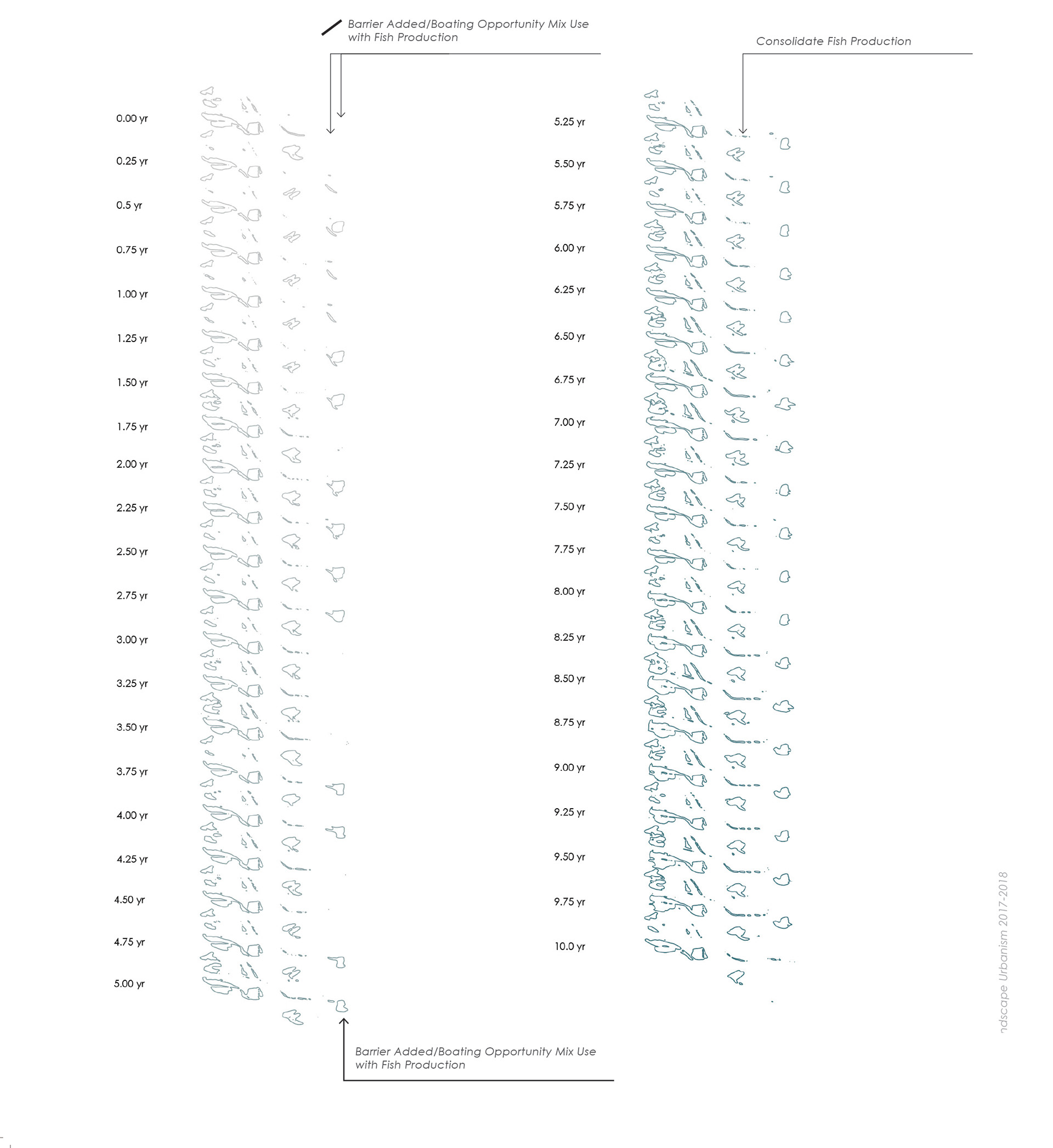
The project utilizes the physical simulation as seen in the chapter 5. The physical model is instrumental to see the physical impacts along the existing streams. In time, project takes into account scenarios of events that could occur. This is one sample scenario of development through time. Through various iterations, the project can understand the composition of sediment movements and low tide creek formations. In the drawing to the right, structures are place through time responding to the blurring between use on land and water. Programs storage facilities and seafood production industries merging with their adjacencies to create a diverse landscape.
This model is shown as a way of self-managing between many stakeholders and a way of marine management at the micro scale. In today’s marine spatial planning, management has been developed through arbitrary lines and points (Steinberg 258). The marine space is constantly in flux and marine spatial planning does not respond to a constant changing landscape. As a result, the project maps out a scenario by responding with cooperative built structures that encompasses a diverse landscape with a diverse set of programs.
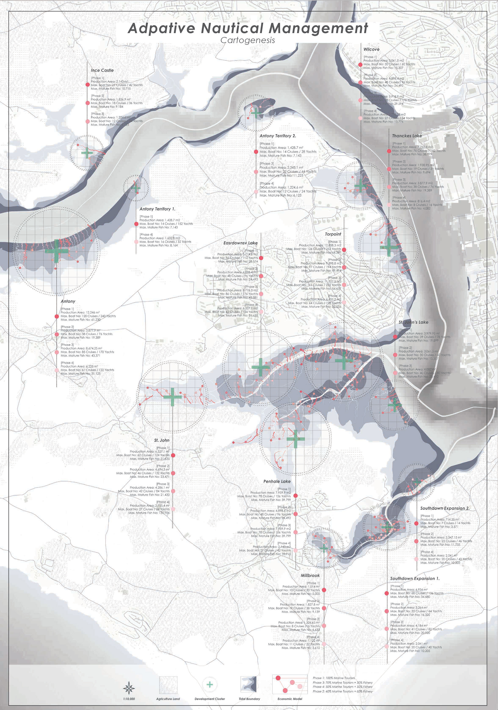
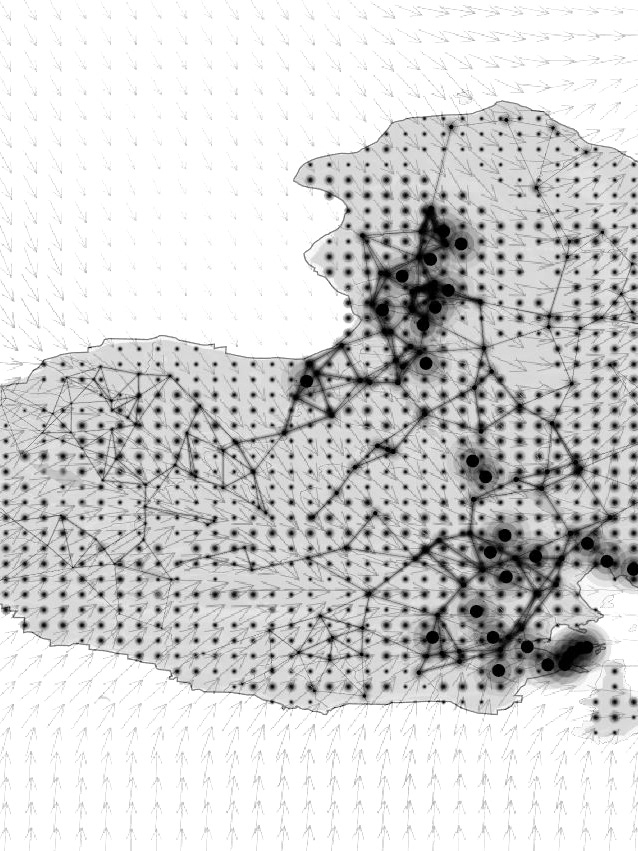
Adaptive nautical management sees opportunity in Plymouth. This chapter addresses the lack of fish boat docking and economic diversification through the development of intertidal areas. More space is allocated throughout Plymouth, but not exceeding a capacity within the existing creek system constraints. Through the development of intertidal creeks, vertical archetypes influence a way of managing intertidal cooperatives from the architectural scale to the regional scale of marine management. In the drawing to the left, the panel locates all existing slipways as potential of development along existing creek systems. The creek system is monitored and managed at a capacity since natural resources influences the success of marine tourism and production industry, as see in the economic scenario diagram, page 42. This coincides with New Economic Foundation’s philosophy of a diverse economy. However, in a designer role, decisions must be made at a higher level to inform design policy with spatial qualities.
In the drawing below, the intertidal areas depict the potential areas of port development that encompasses the capacity of production and vessel storage. Marine spatial planning should be defined by blurring the roles of land and sea as a way of accommodating the varying stakeholders. This becomes a negotiation and dynamic mapping to inform the need of a fluctuating landscape. In addition, economic events and social conflicts are things to consider marine management that is not considered in today’s marine spatial planning. Marine spatial planning is not changing the economy directly, but a way to respond with spatial qualities that help inform cartographic dynamism. Plymouth needs a marine management plan that responds to its advent national marine park proposal.
Intertidal creeks in Plymouth become a proposal that reacts as a territory that serves the local stakeholders as owners to take control of space (Elden 804). Territory or territoriality is not confined to only land but the interface of land and water. The ownership of coastal areas plays a big role in Plymouth. Local fishers play a role in the estuary as much as the recreational activities and the boating activities. The role in which designers consult stakeholders provide a change on how intertidal areas can be altered as oppose to the conventional mudflat creeks of navigation and leisure. Intertidal areas are a territory of interest and provides opportunity for development within the capacity of natural resources relied on marine tourism and the fishing industry (Balata 21). A better marine management across the architectural scale and regional scale is a better resilient coastal community.
Works Cited
Balata, Fernanda. The Blue New Deal. New Economic Foundation, June 2015, 1-56. New Economic Foundation, https://neweconomics.org/.
Bioaqua. “Consultancy.” Bioaqua Farm, bioaquafarm.co.uk/consultancy/.
Carpenter, Griffin. “Not in the Same Boat.” New Economic Foundation.
Cosgrove, Denis E. Social Formation and Symbolic Landscape. University of Wisconsin Press, 1998.
“Earth Ocean Farms.” Earth Ocean Farms, www.earthoceanfarm.com/.
Elden, Stuart. The Birth of Territory. The University of Chicago Press, 2013.
Ellis, Tim, et al. “CEFAS.” Aquaculture Statistics for the UK, with a Focus on England and Wales, Cefas, Jan. 2015, assets.publishing.service.gov.uk/government/uploads/system/uploads/attachment_data/file/405469/Aquaculture_Statistics_UK_2012.pdf.
Fraser, Douglas. “Scottish Salmon Farming’s Sea Lice ‘Crisis’.” BBC News, BBC, 14 Feb. 2017, www.bbc.co.uk/news/uk-scotland-38966188.
Gandy, Matthew, The Fabric of Space: Water, Modernity, and the Urban Imagination. Massachusetts Institute of Technology, 2014, pp. 145-183.
Glegg, Gillian, Et al. “Plymouth National Marine Park, Interview.” 22 Mar. 2018.
“GreenWave.” GreenWave, www.greenwave.org/greenwaveorg/.
Lerøy. “Ocean Forest.” Lerøyseafood, www.leroyseafood.com/en/sustainability/innovation/ocean-forest/.
“Marine Protected Areas in the UK.” Marine Protected Areas in the UK, jncc.defra.gov.uk/page-5201.
Mzgoulton. “‘No-Take’ Marine Reserves in the UK.” Enviro-Blog, 11 Nov. 2014, mzgoulton.wordpress.com/2014/11/11/no-take-marine-reserves-in-the-uk/.
Plymouth City Council. “Plymouth Report 2017.” Plymouth, Oct. 2017, Plymouth.gov.
Rutgar. “What Is the Difference between Marine Reserves and Marine Parks? -.” Book Your next Adventure Trip Today, The Scuba Page, 5 Feb. 2018, rushkult.com/eng/scubamagazine/marine-reserves/.
Steinberg, Philip and Peters, Kimberley. Wet Ontologies, Fluid Spaces: Giving Depth to Volume through Oceanic Thinking. Sage Journals, 2015. 247- 265. Sage Journals, journals.sagepub.com/doi/10.1068/d14148p.
Veta La Palma. “Welcome to VETA LA PALMA.” Veta La Palma - Parque Natural, www.vetalapalma.es/index.asp?LG=2.
Veta La Palma. “Welcome to VETA LA PALMA.” Veta La Palma - Parque Natural, www.vetalapalma.es/index.asp?LG=2.